


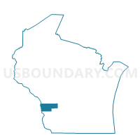
HAMBURG - T 1 Voting District, Vernon County, Wisconsin
About
Outline

Summary
| Unique Area Identifier | 697346 |
| Name | HAMBURG - T 1 Voting District |
| County | Vernon County |
| State | Wisconsin |
| Area (square miles) | 28.76 |
| Land Area (square miles) | 28.71 |
| Water Area (square miles) | 0.05 |
| % of Land Area | 99.82 |
| % of Water Area | 0.18 |
| Latitude of the Internal Point | 43.69826450 |
| Longtitude of the Internal Point | -91.11014100 |
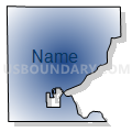
Maps


Graphs
Select a template below for downloading or customizing gragh for HAMBURG - T 1 Voting District, Vernon County, Wisconsin


Neighbors
Neighoring Voting District (by Name) Neighboring Voting District on the Map
- BERGEN - T 1 Voting District, Vernon County, WI
- Chaseburg - V 1 Voting District, Vernon County, WI
- COON - T 2 Voting District, Vernon County, WI
- GREENFIELD - T 1 Voting District, La Crosse County, WI
- HAMBURG - T 2 Voting District, Vernon County, WI
- HARMONY - T 1 Voting District, Vernon County, WI
- SHELBY - T 2 Voting District, La Crosse County, WI
- WASHINGTON - T 1 Voting District, La Crosse County, WI
Top 10 Neighboring County Subdivision (by Population) Neighboring County Subdivision on the Map
- Shelby town, La Crosse County, WI (4,715)
- Greenfield town, La Crosse County, WI (2,060)
- Bergen town, Vernon County, WI (1,364)
- Hamburg town, Vernon County, WI (973)
- Harmony town, Vernon County, WI (755)
- Coon town, Vernon County, WI (728)
- Washington town, La Crosse County, WI (558)
- Chaseburg village, Vernon County, WI (284)
Top 10 Neighboring Place (by Population) Neighboring Place on the Map
Top 10 Neighboring Unified School District (by Population) Neighboring Unified School District on the Map
- La Crosse School District, WI (62,886)
- Viroqua Area School District, WI (8,693)
- Westby Area School District, WI (7,569)
- De Soto Area School District, WI (4,375)
Top 10 Neighboring State Legislative District Lower Chamber (by Population) Neighboring State Legislative District Lower Chamber on the Map
Top 10 Neighboring State Legislative District Upper Chamber (by Population) Neighboring State Legislative District Upper Chamber on the Map
Top 10 Neighboring 111th Congressional District (by Population) Neighboring 111th Congressional District on the Map
Top 10 Neighboring Census Tract (by Population) Neighboring Census Tract on the Map
- Census Tract 107, La Crosse County, WI (5,484)
- Census Tract 9606, Vernon County, WI (4,614)
- Census Tract 9607, Vernon County, WI (4,017)
- Census Tract 108, La Crosse County, WI (3,302)